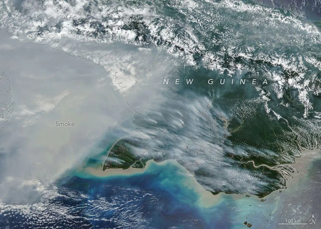
Satellite data shows that 313,777 hectares burned across Indonesia’s six Papua provinces between January and September 2026, accounting for 28% of the country’s total burned area. South Papua recorded the greatest losses, raising concerns about the region’s savannas, wetlands, forests and wildlife.
While forest and land fires in Kalimantan and Sumatra have attracted national attention, Papua has experienced Indonesia’s largest regional burned area during the first nine months of 2026.
Data from MapBiomas Fire Indonesia, analysed by Landscape 360 in a report published on November 2, reveals the geographical scale of the fires.
Across Indonesia, satellite mapping identified more than 1.1 million hectares of burned land during the same period.
South Papua Accounts for Most of the Burned Land
South Papua recorded 253,274 hectares burned, making it Indonesia’s most affected province by burned area.
Merauke Regency accounted for 192,479 hectares, followed by neighbouring Mappi Regency with 53,481 hectares.
The fires spread across landscapes that include tropical forests, wetlands, grasslands and extensive savannas.
However, burned land should not automatically be classified as destroyed rainforest.
According to Landscape 360, most of the mapped burned area in Merauke consists of natural non-forest vegetation, particularly savannas and swamp grasslands.
These environments experience fire differently from tropical forests. Some grasslands burn seasonally, while repeated or unusually intense fires can alter vegetation and affect wildlife habitats.
Understanding these differences is essential when assessing the ecological consequences.
Fires Also Affect Papua’s National Parks
Protected landscapes have not escaped the fires.
In Wasur National Park, near Indonesia’s border with Papua New Guinea, satellite data recorded 21,278 hectares burned between January and September.
According to Katadata, Wasur had the largest mapped burned area among Indonesia’s national parks during that period.
Papua supports exceptional biodiversity, including birds-of-paradise, endemic mammals and species found nowhere else.
Fire can affect feeding grounds, shelter and vegetation. Yet the consequences vary depending on the ecosystem, fire intensity and frequency.
The full ecological impact of the 2026 fires has not yet been established.
Why Satellite Data Reveals a Different Fire Crisis
Satellite monitoring provides several ways to measure fires, but the results do not always tell the same story.
Hotspots identify thermal anomalies, while burned-area maps estimate the land affected by fire.
In Kalimantan, peat fires can smoulder for extended periods, producing repeated satellite detections.
In Papua, fires across open savannas and grasslands can spread quickly over large areas, leaving fewer detections per hectare.
This helps explain why Kalimantan recorded more hotspots while Papua accounted for a larger share of Indonesia’s mapped burned area.
The distinction is important: hotspot counts alone cannot measure the total land burned.
Fire Emergency Measures Continue in November
The threat remains active in parts of Indonesia.
On November 3, the Ministry of Forestry confirmed that South Papua’s fire emergency status would remain in effect until November 28, 2026.
Authorities have continued patrols, ground firefighting and weather modification operations intended to encourage rainfall.
Dry conditions and land-clearing practices remain important concerns. However, the cause of every individual fire has not been established.
Officials have also stressed that satellite hotspots require verification on the ground.
What Papua’s Fires Mean for the Region
Papua’s 2026 fire season illustrates how environmental emergencies can unfold across very different ecosystems.
The region recorded Indonesia’s largest share of burned land through September, but the figures alone cannot determine the extent of ecological damage.
Further field assessments are needed to understand how affected habitats, wildlife populations and local communities will recover.
For one of Indonesia’s most biologically distinctive regions, the long-term consequences remain an important question.
Hero photograph: Satellite imagery showing fire-scarred landscapes in New Guinea, October 11, 2026. Credit: NASA Earth Observatory / Michala Garrison.
Follow us on Instagram and Facebook to stay informed
This article may be of interest to you: As Rain Returns to Borneo, Orangutans Face an Uncertain Future